

Date
Fri. July 9, 2027
Start Time
4:20 PM
Time Limit
38h40m or until you quit
Field Limit
100
Elevation Change
~22,800 feet
Start Location
Lithia Park (The Plaza), Ashland, OR
Bib Pick-up
1PM 7/10 (Lithia Park)
Cost
$420
Qualifier
Western States 100 qualifier
View official crew driving directions and GPS coordinates for crewable SOB Brink 100m aid stations here
Space is limited to the first 100 runners. $420 entry fee before June 1st, 2027, and $500 after. Sorry, no refunds will be given.
Special awards to overall male and female winners. All finishers received a Brink 100 buckle and embroidered ACG travel bag.
The closest airport is in Medford Oregon (MFR), which is a 20 min drive from the start in downtown Ashland.
All entrants receive a premium Nike Dri-Fit ACG tee with custom front and back embroidery
The Ashland Springs Hotel, located 3 blocks from Lithia Park and the start of The Brink. Other local options include: Palm Cottages, Super 8, Holiday Inn Express, Plaza Inn Ashland
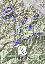
From town to summit, the Brink 100 starts in the heart of Ashland and finishes high at Mt. Ashland Lodge. With over 23,000 feet of climbing, two 5,000-foot ascents, high points above 7,000 feet, and stunning stretches of the Pacific Crest Trail, it’s a true mountain hundred.
The Brink 100 starts in the late afternoon in downtown Ashland and quickly heads into the Ashland Creek Watershed and up the first of two 5,000-foot climbs. Runners begin with the gravel of the 2060 Road before hitting Rickity and No Candies trails. After No Candies, there is a little more 2060 Road running before the steepest part of the climb up Wagner Glade Trail to Wagner Glade Gap, and on to the first 7,000-foot peak — Wagner Butte (with its small and sporty summit).
After taking a few moments to admire the view from Wagner Butte and the sunset (or moonrise — depending on your pace), runners head back down to Wagner Glade Gap and turn right, dropping down into the Wagner Creek Watershed. From there, you take a mix of trail and rolling fire road up and down (and mostly up) around Bald Mountain, with views of the twinkling lights of the Rogue Valley far below.
At Anderson Butte, you will hit the very remote Jack Ash Trail and drop down into the Applegate River Watershed. At this point, the sun will be rising for many runners, and the course hits the Sterling Ditch Trail, offering some much-needed flat running. But don’t worry! Partway along the ditch, the course makes a quick and beautiful detour up (we don’t want too much flat) and down along the Wolf Gap Trail before connecting back to the ditch.
At the end of the ditch, runners will have a chance to pick up their pacer before beginning the second, and probably most grueling, 5,000-plus-foot climb of the race. The climb begins with gravel Forest Service roads to the Glade Creek Aid Station before things get spicy — a beautiful and very remote 3,000-plus-foot climb in a little over six miles along the rarely visited 7 Mile Ridge Trail. The trail climbs along the main northern ridge of Big Red Mountain before contouring the east face and hitting the Siskiyou Crest.
From here, you meet the final two-thirds of the SOB 50K and run a mix of the Pacific Crest Trail and Forest Service roads. However, the Brink 100 does send you on a quick and scenic detour from the 50K and 100k routes with an out-and-back to the top of your second 7,000-foot peak of the race — Dutchman Peak.
After Dutchmans, runners follow the end of the 50K and 100K courses along some of the most spectacular stretches of the PCT and finish, as all our longer SOB courses do, with the final climb up the backside of Mt. Ashland (the 3rd and tallest of the 7,000-foot peaks on the course) and a short, steep, descent to the finish at Mt. Ashland Lodge.
Phew… At that point, runners will have climbed over 23,000 feet, tackled two 5,000-foot ascents, and reached three points above 7,000 feet.
The Siskiyou Out Back (SOB) is a non-profit organization and all profits benefit local non-profit organizations. In total, we have given over $200,000 to various non-profits in the last ten years. In 2022 we contributed to Ashland Trails Outdoor School, Family Nurturing Center, Siskiyou Mountain Club, Come Back Alive, a Ukrainian non-profit, and to our partner, Mt. Ashland Ski Area.